2015 March: Mt Sentinel, Kosciuszko National Park, NSW, Australia
Prolog
Today, Adam, Daniel, Saf and I are meant to climb
Mt Sentinel
Tenison Woods Knoll (aka Watsons Crag Dome and also Mt Dubious)
Watsons Crags
Mt Twynam
Mt Anton
in the Kosciuszko National Park.
Unfortunately, on the way to Mt Sentinel, Adam injures his Achilles tendon. Hence we cut short our walk and climb Mt Sentinel only. As the afternoon is still early, after we return to the car, we go on to climb the nearby Mt Stilwell, minus Adam.
Mt Sentinel
Most hikers on the Main Range Track in Kosciuszko National Park would have seen Mt Sentinel from a distance and would have marvelled at its pyramid-shaped peak standing alone, out at the end of a ridge like a sentinel.
As it is only 1905 meters, it is dwarfed by many 2000-meter plus peaks around that area. Hence not many people would bother to climb it ... and I have to admit, including me ... until one day, Adam said we MUST climb it.
It turns out that the walk along the ridge to its summit is like walking on the edge of a razorblade; slopes dropping off sharply on both side ... definitely one the more memorable hikes I've taken ... Thank you, Adam !
Maps
1:100,000 8525 Kosciuszko
1:50,000 Kosciuszko Alpine Area map, 1st edition, by Spatial Vision Innovations Pty Ltd
1:25,000 8525-2S Perisher Valley
Below is the relevant part of the 1:25,000 scale map:

GPS tracklog file & Route
Our GPS tracklog file can be downloaded from:
KML: https://drive.google.com/file/d/0B877-h5SCJaScll0a0FMbzlGSE0/view?usp=sharing
GPX: https://drive.google.com/file/d/0B877-h5SCJaSY1BDRmpHYU5uY3c/view?usp=sharing
The same tracklog in red superimposed on the 1,25,000 scale map:

The corresponding satellite image:

In summary:
- Park car at Charlotte Pass.
- Walk on Main Range Track.
- At some point on the Main Range Track, veer off to climb Mt Sentinel.
- Return trip is by re-tracing steps back to the car.
Timeline & Distance
08:11 0.0 km Start at Charlotte Pass
09:30 4.0 km at junction of Main Range Track & Blue Lake Walk
09:34 4.0 km leave junction of Main Range Track & Blue Lake Walk
11:37 7.2 km at Mt Sentinel summit
11:58 7.3 km leave Mt Sentinel summit
12:34 8.0 km stop for lunch
Lunch
12:54 8.0 km start walking
14:01 10.6 km at junction of Main Range Track & Blue Lake Walk
14:51 14.4 km Finish at Charlotte Pass
===================================
Total: 6 hr 40 min at leisurely pace (due to Adam's injured Achilles tendon)
14.4 km - Distance is from Google Earth.
15.8 km - Distance is from Garmin GPS.
Pictures - Snowy River
1) We start the morning at Charlotte Pass. Walk on a track, called Main Range Track which heads towards Blue Lake. In the pic, the track first crosses Snowy River, then Club Lake Creek. (This pic is taken in the afternoon when we are returning to Charlotte Pass.)
The mountains in the distance are on the Main Range:
- The left arrow points to Mt Lee.
- The right arrow points to Carruthers Peak.

2) Crossing Snowy River ~~~ It is foggy in the morning. (The fog won't stay for long.)

To Mt Sentinel
3) An interesting fog rainbow, caused by the morning fog.

4) Nice red colour ~~~ The plant is Richea; but which species ?

5) Spider Web

6) While on the way to Blue Lake, if you look back towards Charlotte Pass, you'll see Kangaroo Ridge with Mt Stilwell, 2054 meters, at the middle.
- Upper pic: Mt Stilwell is smack bang in the middle of the pic. The red arrow points to the front end of Little Stilwell. The Little Stilwell summit is a little bit to the right of the arrow. We'll climb Mt Stilwell this afternoon, but not Little Stilwell.)
- Lower pic: The red arrow points to the same front end of Little Stilwell. The Little Stilwell summit is a bit more to its right. Mt Stilwell is on the right side of the pic and is the highest point to the right of the red arrow.

7) (Photograph courtesy of Daniel ... Click on the image to enlarge it.)
On the way to Blue Lake is this broad vista of Kangaroo Ridge, Rams Head Range and Main Range.
From left to right, the arrows point to:
- Front end of Little Stilwell. Mt Stilwell is not too far to its right.
- North Rams Head
- Etheridge Ridge
- Mt Clarke (Mt Kosciuszko is behind Mt Clarke, not visible here.)
- Mt Northcote
- Mt Lee
- Carruthers Peak

http://mntviews.blogspot.com.au/2014/11/etheridge-ridge-kosciuszko-rams-head.html has photos and a write up on my climb to North Rams Head, Etheridge Ridge and Mt Kosciuszko.
http://mntviews.blogspot.com.au/2014/12/lee-northcote-clarke-abbott-range.html has photos and a write up on my climb to Mt Clarke, Mt Northcote, Mt Lee, Carruthers Peak and Mt Kosciuszko.
8) The previous photo is taken in the afternoon when we are returning to Charlotte Pass. Whereas this one is taken in the morning with the fog lingering around. (Click on the image to enlarge it.)
From left to right, the arrows point to:
- North Rams Head
- Etheridge Ridge
- Mt Clarke (Mt Kosciuszko is behind Mt Clarke, not visible here.)
- Mt Northcote
- Mt Lee
- Carruthers Peak

9) On the way to Blue Lake

10) Still on the way to Blue Lake ~~~
Don't even think about it ... cars are not allowed on this road.

11) Crossing an unnamed creek.

12) At a T-junction ~~~ We'll turn left here. (Turning right is to Blue Lake which is on the right edge of this photo.)
- The left arrow points to Mt Twynam, 2196 m, Australia's 3rd highest mountain.
- The right arrow points to Little Twynam.

By the way, depending on the sun's position, Blue Lake can be beautifully blue. It is also one of only five glacial tarns in mainland Australia. The other four are Hedley Tarn (see photo #31), Club Lake, Lake Albina and Lake Cootapatamba.
13) Half a kilometer out from the T-junction of the previous photo, we encounter this interesting rock formation - looks like a dragon, or the spine of a dinosaur.

14) 1 hour 40 minutes after we started walking, Mt Sentinel comes into view.
Most hikers on the Main Range Track would pass by this spot and would stop to admire at the view. But most would not bother to climb Mt Sentinel. I have to admit Mt Sentinel was not high on my list of mountains to climb ... until one day, Adam said we MUST climb it. It turns out that the walk along the ridge to its summit is like walking on the edge of a razorblade; slopes dropping off sharply on both side ... definitely one the more memorable hikes I've taken.
In the lower photo, the arrows point to (from left to right):
- Carruthers Peak
- Alice Rawson Peak (Abbott Range)
- Mt Sentinel
- Tenison Woods Knoll

15) We are approaching the ridge along which we'll walk towards Mt Sentinel.
(Click on the image to enlarge it.) From left to right, the arrows point to:
- Carruthers Peak
- Mt Townsend (Compared to the previous photo, we are seeing more of the Abbott Range)
- Alice Rawson Peak (Abbott Range)
- Mt Sentinel
- Tenison Woods Knoll
- Mt Twynam

16) Now at the start of the ridge to Mt Sentinel.
We can clearly see the valleys on either side of the ridge.
- Strzelecki Creek flows down the valley on the right.
- An unnamed creek flows down the valley on the left.
(Both of them flow into Lady Northcote Creek.)
All the peaks in the Abbott Range are also in view ... from left to right, the arrows point to:
- Byatts Camp
- Abbott Peak
- Mt Townsend
- Alice Rawson Peak

http://mntviews.blogspot.com.au/2014/12/lee-northcote-clarke-abbott-range.html
17) One of the head waters of Strzelecki Creek which flows down the valley on the right side (north side) of Mt Sentinel.

18) Are these flower petals dying? (It is March now, the beginning of Autumn.)

19) These little yellow flowers are still blooming.

20) Monistria concinna (Spotted Mountain Grasshopper) ~~~
They are interesting:
- They only live in the Australian Snowy Mountains region.
- They cannot fly and are not strong hoppers, so they cannot readily flee from predators.
- Their skins contains noxious chemicals – skinks will avoid them after a single encounter.
- They manufacture their own anti-freeze and are very cold-tolerant. Nevertheless, they like to seek sunny rocks and bare ground on which to bask and mate.

21) Wolf Spider ~~~ it blends well with the background.

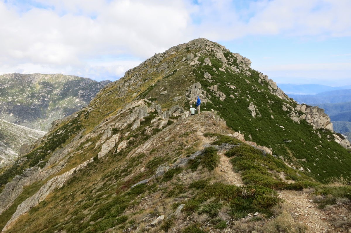
22) Walking on the ridge to Mt Sentinel ~~~
You can clearly see the track along the ridge top - it is like walking on the edge of a razorblade, slopes dropping off sharply on both sides !

23) It is interesting that the slope on the right (the north side) is so much greener. Is it because the north side receives more sun light and the snow melts earlier there?
By the way, in the middle of the pic, at where Saf and Adam are, there is a sharp drop and it is not easy to get through there. If you are afraid of height, you may need to find another way to get around that point.
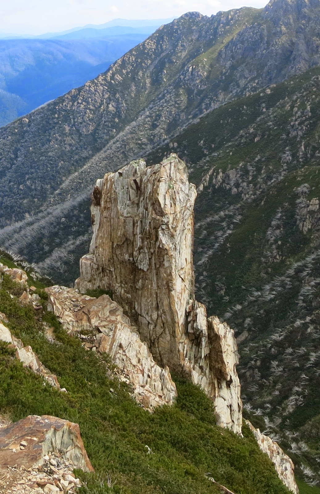
24) An interesting rock formation on the slope of Mt Sentinel
Mt Sentinel Summit
25) Almost at the summit

At Mt Sentinel Summit
26) At the summit, 1905 m ~~~
Clockwise: Adam, Paul, Saf, Daniel

27) View from the summit towards the west ~~~
There is no higher mountains further to the west.

28) Clouds start to roll in (only temporarily) ~~~
We are at the summit, looking back towards the spot where we first saw Mt Sentinel (that is where photo #14 was taken). And we can see people standing there. They have been there for sometime, watching us climbing up the summit !!! (The lower photo is zooming into the red square of the upper photo.)

The return trip
29) The return trip is simply retracing our steps along the ridge top back to the main plateau.

30) This place is near the spot where the people were watching us in Photo #28.
- Mt Sentinel is the little pyramid in the middle of the photo.
- The cloud formation just above it is very interesting ... like a train of something :-)

31) Hedley Tarn is seen here on our way back to the car at Charlotte pass.
The red arrow at the top right hand corner points to the front end of Little Stilwell.

Post Script - Mt Stilwell
After we are back at the car, as the afternoon is still early, we go on to climb Mt Stilwell, minus Adam. Mt Stilwell is 2054 meters, one of the above-2000-meter peaks in Australia that is on my list to climb.
Almost 2 year later, in 2016-12, Adam, Daniel & I return to climb Mt Stilwell & Kangaroo Ridge. Photos and trip report are in my blog:
http://mntviews.blogspot.com.au/2016/12/mt-stilwell-and-kangaroo-ridge.html
No comments:
Post a Comment