2016 January: Short stroll to Mt Eden summit, New Zealand North Island
Mt Eden
Mt Eden (Maungawhau in Maori) is a dormant volcano in Auckland, New Zealand North Island. Its top is a beautiful bowl-like crater 50 meters deep. The highest point on the crater rim is 196 meters (643 feet), and is also the highest point on the Auckland isthmus. As it is the highest point of something, so I just have to give it a visit :-)
The top of the mountain (can it be called a mountain if it is only 196 meters high?) provides a good view in all directions over Auckland. There used to be a large number of tourist buses driving up to the summit. They were banned in 2011. In 2016 1st of January, the ban was extended to all cars ... Damn ! I am here at the end of January 2016 and I have to walk ! Ggrrr !
Naming
Maungawhau means the Mountain of the Whau Tree (Entelea arborescens). The name "Mt Eden" was to honour George Eden, 1st Earl of Auckland. The crater is called Te Ipu-a-Mataaho, the bowl of Mataaho. Mataaho was a deity said to live in the crater and to be the guardian of the secrets hidden in the earth.
Map
- The small blue circle is where I park the car.
- The larger blue circle is the nearest carpark to the summit. However all the carparks around there are full. Hence the reason why my car is parked further away.
- The 2 blue bars across the roads are gates preventing cars from driving to the summit.

GPS tracklog file & Route
The GPX tracklog file of my stroll can be downloaded from:
https://drive.google.com/file/d/0B877-h5SCJaSdmQxbFlOVkt0LWM/view?usp=sharing
Also refer to the below map where my route is in turquoise colour:
- Start at the carpark - small blue circle.
- Walk in clockwise direction.

Timeline & Distance
19:59 0.0 km Start from carpark
20:07 0.7 km At viewing platform east of Mt Eden summit
20:08 0.7 km Leave viewing platform
20:09 0.8 km At Mt Eden summit
Explore around
20:12 0.8 km Start to return to car
20:13 0.9 km At viewing platform east of Mt Eden summit
20:24 1.8 km Finish at carpark
==============================================
Total: 25 mins
1.8 km Distance is from Google Earth
2.0 km Distance is from GPS
Pictures - Mt Eden from a distance
1) Mt Eden from One Tree Hill (I was at the top of One Tree Hill prior to visiting Mt Eden.)

2) Now driving from One Tree Hill toward Mt Eden ~~~
This photo of Mt Eden is taken from Mt Eden Rd, and near the junction with Balmoral Rd.

Stroll to Mt Eden summit
3) I've parked my car and now walking up to Mt Eden. There is a road that you can walk on. (The road is now closed to all cars.) But I take a short cut, the yellow arrow.

4) The short cut soon leads to a foot track. The crater rim is in front.

5) A short set of steps to climb up ...

6) ... It leads to another view of the crater rim.

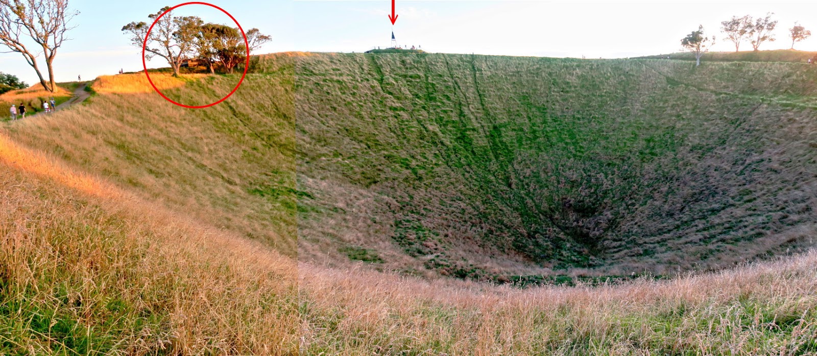
7) A minute later, you come to this magnificent view of the crater.
- The red arrow points to the summit which doubles up as a viewing platform.
- There is another viewing platform at the red circle. I'm heading there first.
8) At the same spot as where the previous pic was taken ... zooming in across the crater at the summit.

9) Now at the viewing platform - the red circle in photo #7

10) From the viewing platform, looking towards the summit - about 70 meters to the west ~~~
It is getting late. The sun is setting.

Mt Eden summit
11) The summit ~~~
The thingie in the red circle in the lower photo is a direction plaque

12) The direction plaque ... red circle of the previous pic ~~~
It has directions to various landmarks around and outside Auckland. For example, in the lower pic there is a direction to Mt Egmont (ie Mt Taranaki) - 276 km to the south.

http://mntviews.blogspot.com.au/2016/01/mt-taranaki-sharks-tooth-new-zealand.html
13) An obelisk erected as a survey mark on 1872-08-17

14) Looking towards the north, across the crater, with Auckland CBD in the background

15) Zooming in onto Auckland ~~~
- The tall tower is Sky City / Sky Tower.
- The bridge on the left edge is Auckland Harbour Bridge. The Northern Motorway (Motorway 1) goes over the bridge.
- I stay in a hotel by the edge of the harbour somewhere behind the buildings in the red oval. (The buildings blocks the view to the hotel.)

16) Still at the summit - panoramic view of Auckland ~~~
This view is from north to south-east.
The red arrows point to, from left to right:
- Mt Hobson (directly east)
- Mt Saint John
- One Tree Hill (towards south-east) is just outside the left edge of this photo ... see photo #17 ...

17) (Towards south) Continuation to the right of previous pic ~~~
The red arrow points to One Tree Hill, towards south-east.

18) Zooming onto One Tree Hill ~~~
I was at its top 40 minutes ago at 7:25pm. Unlike here at Mt Eden, one can drive a car all the way to its top ... But maybe not for long ... The road to the top is narrow; and too many cars driving up; and the amount of parking spaces there is limited. Sooner or later, cars will be banned from driving up.

Post Script
It is a nice pleasant stroll to Mt Eden, well worth a visit - you'll love the volcano crater and the view of Auckland.
You may also like to visit One Tree Hill - you can drive all the way to the top.
Thanks so much for taking the time. Super helpful. You're awesome!! Cheers
ReplyDelete