2016 October: Day walk - Dicksonia Forest Ravine, Blue Mountains, NSW, Australia
And pagodas above Little Dickson Gully
Prolog
- Dicksonia Forest Ravine
The ravine gets its name from a forest of Soft Tree Ferns, Dicksonia antarctica, in a levelish section of a gully between Deep Pass Trail and Dingo Creek, in the north-western corner of Blue Mountains National Park, NSW.
- What is special about the ravine and the tree ferns?
Well, in the ravine, a large number of the Dicksonias are fallen or bent into an arch. On reaching the ground, the stems turn vertical and continue to grow and hence having the appearance of giant caterpillars crawling all over the forest.
Thus the ravine is like an enchanted world, like a mythical fairy land ... see photographs later on in this report.
I have been here before, 5 months ago in 2016-05 with DH. The ravine is so interesting that I decide to come back for a re-visit, this time with MK.
- Pagodas above Dingo Creek, specifically above Little Dickson Gully
Today with MK, we also climb up the cliffs to the plateau above Dingo Creek and explore some of the pagoda-like rock formations there. (DH and I didn't go there in our earlier trip.)
We climb up via a small gully (GR 489 049 to 490 049) which I have since named as "Little Dickson Gully". The gully is about 70 meters long, not drawn in the 25,000-scale topographic map, but it is visible in a satellite image.
( Post script: The name "Little Dickson Gully" is now registered in Bush Explorers' website:
http://www.bushexplorers.com.au/encyclopaedia/little-dickson-gully )
Book
"The Gardens of Stone - Book 4" by Michael Keats and Brian Fox
Walk Number 4.8 describes a trip to this area by Michael Keats and his party in 2012-11-16.
But I only have access to the book well after our walk is over.
Map
- 1:100,000 scaled 8931 Wallerawang
- 1:25,000 scaled 8931-2N Rock Hill
Below is the relevant part of the 1:25,000 scaled map.

GPS tracklog file & Route
The GPX tracklog file of our walk can be downloaded from:
https://drive.google.com/file/d/0B877-h5SCJaSQzAwZVV2aThHc0U/view?usp=sharing
Our tracklog in red colour, clockwise direction:
- The main part of our walk, the circuit, is at the north-western corner of Blue Mountains National Park, right at the junction of Newnes State Forest, Wollemi National Park and Blue Mountains National Park.
- Blue dot: Where I park my car, exactly 2 km east of Glowworm Tunnel Rd.
- If you have a 4-wheel-drive car, you can drive the car further east to near where the circuit is, thus shaving off about 3 km of walk on Deep Pass Trail.


Another view of the tracklog in red colour, clockwise direction:
- 2 blue arrows: Dicksonia Forest Ravine is the section between the 2 arrows. Caterpillar-like Soft Tree Ferns, Dicksonia antarctica, grow in this ravine.
- Blue circle: Some caterpillar-like Soft Tree Ferns also grow in here.
- Pink dot: Cliff above Dicksonia Forest Ravine ... 5 months ago in 2016-05, DH and I went to here first (photo #3) before descending down into the ravine
- Blue dots: On our return leg, we should have followed the blue dots back to Deep Pass Trail. That was how DH and I did it in 2016-05. Instead, we take the red route today and encounter some cliffs which make progress difficult.


Closer look at the southern part of today's route (Click on the image to enlarge it.) ~~~
- The numbers 1 to 6 are Pagodas #1 to #6 in the trip report.
- Yellow oval: GR 489 049 to 490 049, Little Dickson Gully ... A name I've just made up for a gully about 70 meters long. It is not drawn in the 25,000-scale map, but it is visible in this satellite image.
- 3 turquoise arrow from left to right:
• Where we have lunch
• The pagoda I like to climb but didn't
• Where Little Dickson Gully ends and where we climb up to the cliff above.

A summary of our route is:
- Park car at Deep Pass Trail exactly 2 km east of Glowworm Tunnel Rd
- Walk along Deep Pass Trail for 3.1 km
- Turn south and bushbash into Dicksonia Forest Ravine
- Walk through the ravine in the direction of Dingo Creek
- Round the cliffs and walk towards the mouth of Little Dickson Gully
- Turn into and go up Little Dickson Gully
- Climb up the cliff at the end of Little Dickson Gully
- Visit Pagodas #1 to #6 ... refer to the above satellite image
- Turn south and descend a gully towards Dingo Creek
- Round the cliff and go up the next gully on the west side
- To Deep Pass Trail
- Back to car along Deep Pass Trail
Timeline & Distance
08:43 0.0 km Start walking (car parked at Deep Pass Trail exactly 2 km east of Glowworm Tunnel Rd)
09:16 3.1 km Leave Deep Pass Trail, turn south and start bushbashing towards Dicksonia Forest Ravine
09:29 3.3 km Start of Dicksonia Forest Ravine
09:46 3.8 km End of Dicksonia Forest Ravine, start of steep descend
11:00 5.3 km At mouth of Little Dickson Gully
11:04 5.4 km At end of Little Dickson Gully
MK set up climbing tape for me to climb up the cliff
11:14 5.4 km Finish the short climb up the cliff and is now on the plateau
11:24 5.6 km At top of Pagoda #1
Pack up climbing tape properly and photograph scenery, spider, gecko
11:38 5.7 km Leave pagoda
11:46 5.8 km At top of Pagoda #2
11:47 5.8 km Leave pagoda
11:56 6.0 km At top of Pagoda #3
11:58 6.0 km At top of Pagoda #4
12:06 6.2 km At top of Pagoda #5
Discover my water bladder is leaking
12:13 6.2 km Leave pagoda
12:30 6.5 km At top of Pagoda #6
To find out the best way to climb down the cliffs to the gully below
12:31 6.5 km Leave pagoda
12:59 7.0 km Stop for lunch
Lunch
13:31 7.1 km Resume walking
15:25 9.4 km Reach Deep Pass Trail
16:00 12.0 km Arrive at car
==============================================
Total: 7 hrs 17 mins
12.0 km Distance is from Google Earth
16.5 km Distance is from Garmin GPS (Why such a large discrepancy??? Number not to be trusted !)
Pictures - Deep Pass Trail
Note: Some of the pictures were taken in 2016-05, in a trip with DH to this area.
1) We are walking on Deep Pass Trail.
I only have a 2-wheel-drive car. As some section of the Deep Pass Trail is bit hairy for my car, hence it is parked about 3.1 km away from where we will go off-track. But if you have a 4-wheel-drive, you can shave off this part of the walk.

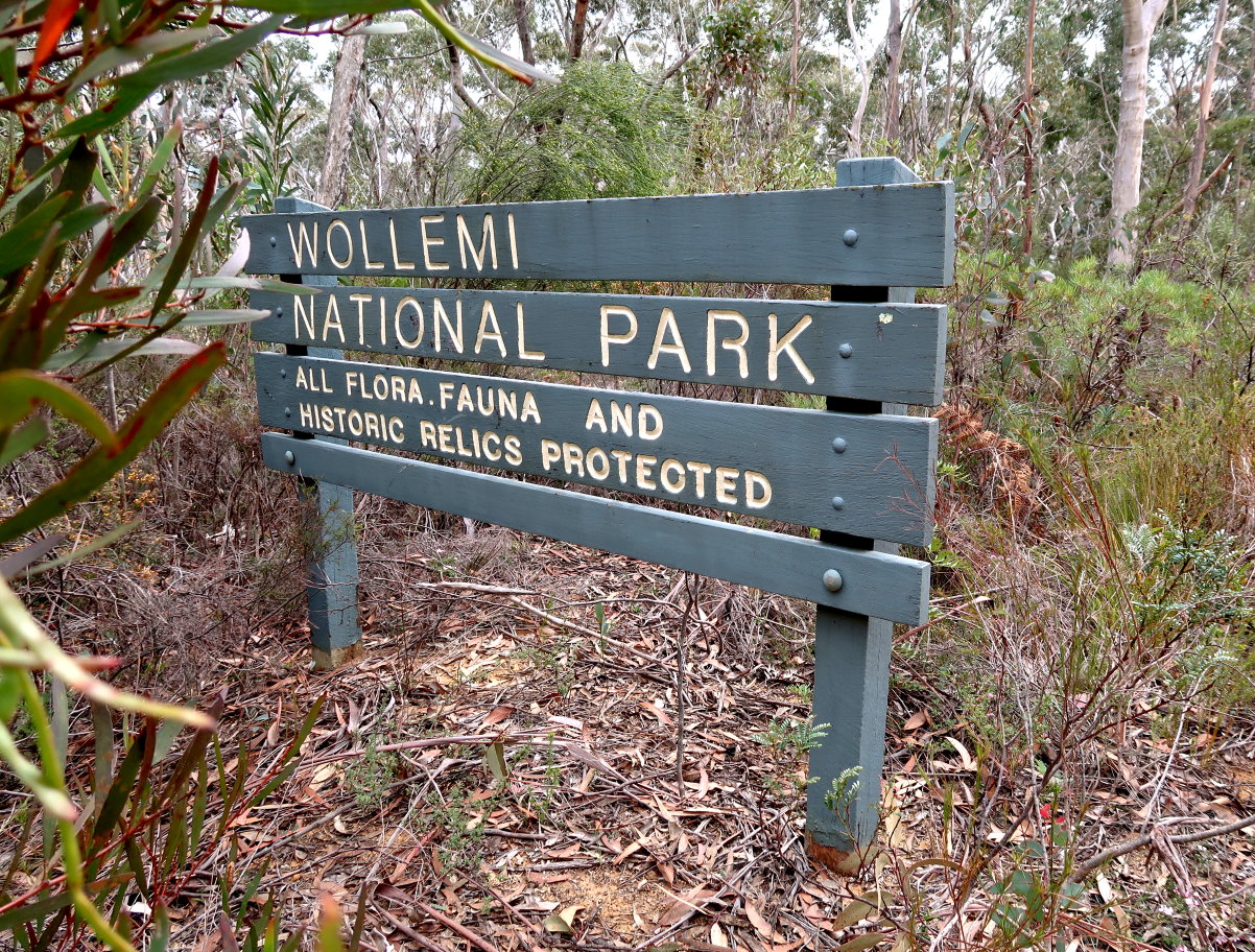
2) Passing this sign on Deep Pass Trail ... It says are entering Wollemi National Park.
This point is the 3-way junction of:
- Newnes State Forest ... where we came from.
- Wollemi National Park .... left side of this sign, ie north side of Deep Pass Trail
- Blue Mountains National Park ... right side of this sign, ie south side of Deep Pass Trail
Cliffs above Dicksonia Forest Ravine
After walking on Deep Pass Trail for 3.1 km, we go off-track, turn right (south) into the bush.
3) In 2016-05, DH and I came here first, the top of the cliffs above Dicksonia Forest Ravine, and peered down into the scrubs below (right side of the photo). From here, high up on the cliff edge, it is not possible to imagine the fairyland-like scene down below!

Dicksonia Forest Ravine and caterpillar tree ferns
4) Today MK and I go headlong straight down into the ravine.
We are now almost directly below the cliffs of the previous pic.

5) The ravine starts to level out; the scenery starts to become interesting ... or enchanting. You'll notice there are plenty of tree ferns around.

6) WOW! The aesthetically spaced tree ferns, the level floor covered with leaves and without a blade of grass ... it's like an enchanted world, a beautiful alien fairy land !

7) Most weird are these Soft Tree Ferns, Dicksonia antarctica ... they are bent, like here.
Of the 2 pics below, the upper pic is taken today. The lower pic was taken 5 months ago in 2016-05. Compare the 2 pics, some twigs and stones on the ground have been shifted. I wouldn't have thought anyone would visit this remote and obscure place in the past 5 months. Could animals have shifted them?

But many Dicksonia antarctica stay up-right. So what make some different and want to bend over? There shouldn't be any wind in this sheltered ravine to blow them over. And maturity may not be a factor as some young Dicksonia antarctica have also fallen over. Let me know if you know the answer.
8) This Dicksonia antarctica has partially tipped over, you can see the roots growing under the trunk. The roots are very fine and shallow.

9) So many of these weird bent-over tree ferns ! ~~~
I almost don't want to write up this trip report ... not keen to have people come trampling around here and damage these beautiful ferns. Hopefully the remoteness of this place would prevent most people from reaching here.

10) Some are bent like an arc, with epiphytic ferns growing on top.
(An epiphyte is a plant that grows harmlessly upon another plant (such as a tree) and derives its moisture and nutrients from the air, rain, and sometimes from debris accumulating around it. Epiphytes differ from parasites in that epiphytes grow on other plants for physical support and do not necessarily negatively affect the host.)

11) This one has saplings growing on the trunk.

12) A beautiful specimen of a caterpillar-like Dicksonia ~~~
The 3 pics below are of the same tree fern (taken from opposite directions).

13) Epiphytic ferns growing on tree trunks ~~~
Also note the interesting twisted vine (the pic on the right).

14) The cliff in this pic is the same as cliff in the previous pic (the pic on the right).

15) Cliff of the ravine

16) Cliffs ... It is the same cliff and plants in both pics.

17) Back to seeing more of the caterpillar-like Dicksonia

18) This pic was taken in 2016-05 with DH.

19) Upper pic: A "green" rock
Lower pic: The cave at the bottom of the green rock ... enough room to accommodate 2 people, but need to crawl in.

20) This pic is taken very close to where the previous one was taken, and marks the end of the magical home of the caterpillar Dicksonias.
- The ravine keeps going and will end at Dingo Creek. We'll go some way towards the creek ... see the trace of our route near the beginning of this report.
- Where MK is standing at the left edge of the pic is the start of a steep drop. Of course we won't shy away from the drop :-)

Towards Dingo Creek
21) This pic doesn't quite show it, but it is a steep drop here. It is also around here I lose my footing going down and hit my forehead on a rock. The eye socket cop the brunt of the impact ... see photo #36. Fortunately the eye itself is spared. What a lucky escape !

22) This is the scene of the gully after climbing down the steep slope mentioned in the previous pic. Still plenty of tree ferns, but none lying on the ground like caterpillars ... why?
The one on the left is also a Dicksonia antarctica. It is holding on to its dead leaves, producing a distinctive brown skirt.

23) The water here is the head source of an unnamed creek that flows down this gully into Dingo Creek.

24) But soon after where the previous pic was taken, it is scrub bashing through thick undergrowth.

25) We keep higher up, closer to the cliffs on the west side of the gully ... because we want to go around this cliff.
By the way, in the 2 pics below, it is the same cliff in both pics. The lower pic is taken after going around the cliff of the upper pic. (Don't ask me about the colour difference between the 2 pics. I don't know why too ... perhaps due to the direction of the sun?)

Along Dingo Creek - to Little Dickson Gully
26) We are now on Dingo Creek, but much higher up.

27) This overhang is quite close to Little Dickson Gully.
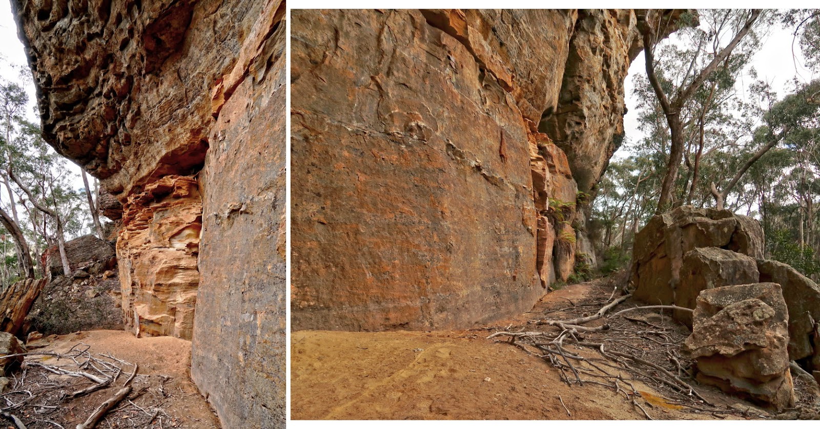
Little Dickson Gully
28) Almost immediately after passing the overhang of the previous pic, we are at Little Dickson Gully ~~~
This gully is not drawn in the 25,000 scale map, but you can see it in the satellite image.
- Upper pic: At the mouth of the gully
- Lower pic: Somewhere inside

But Michael hasn't given a name to this gully, so I take the liberty to name it "Little Dickson Gully" :-)
Post post script: The name "Little Dickson Gully" is now registered in Bush Explorers' website:
http://www.bushexplorers.com.au/encyclopaedia/little-dickson-gully
29) Little Dickson Gully turns out to be quite interesting ... The passage forward is through the hole in the red oval.

30) Straight after passing through the hole of the previous pic, we come to a cliff face. Going further forward requires climbing up the gap in the middle of this pic. Looks climbable, but it will be hairy and won't be easy.

We search around for other ways to climb up the cliff.
31) Looking back at the hole we came through in photo #29 ~~~
It maybe possible to climb up along the yellow arrow and find a way up. But this route also seems difficult.

32) To the left of the cliff in photo #30 is this slope. It looks quite gentle; and indeed MK can scramble up without much hassle. But I just can't do it ... I keep sliding back. Fortunately I have the foresight to bring a climbing tape with me for the trip. So MK climbs up first with the tape and sets it up for me. Then it is just a matter of me grabbing onto the tape and walk up ... easy :-)
By the way, a reasonably long tape is required. There isn't a sturdy tree up the slope. MK has to go up a fair distance to find a reasonably sized bush to anchor the tape. In addition, he also uses his body as anchor. Thanks MK !

To Pagoda #1 above Dingo Creek
33) Once we climb up, it's a different world altogether ... pagoda-like rock formations everywhere ... quite similar to the top of Pantoneys Crown.
We set our eyes on these nearby pagodas ... in particular, we are going to climb to the top of the pagoda on the left, Pagoda #1 (the red oval).

http://mntviews.blogspot.com.au/2016/09/pantoneys-crown-gardens-of-stone-np-nsw.html
34) Now climbing up towards the red oval in the previous pic ~~~
Of the 3 pics below:
- Upper pic: This is where we want to go. But instead of climbing directly up, we first go towards the right a bit.
- Middle pic: Continuation to the right of the upper pic ... somewhere near the right hand side, we climb up.
- Lower pic: Continuation to the right of the middle pic

35) Not quite at the top of the pagoda (red oval in photo #33), but almost ~~~
- This view is centred towards south.
- The top of the pagoda we are aiming for is just beyond the left edge of this pic.
- MK is helping me to tidy up the climbing tape I used to scramble up the the slope in photo #32.
- The pagoda in the red oval is the one in the centre of the previous pic.

At top of Pagoda #1
36) Now at the top of Pagoda #1, red oval in photo #33 ~~~
My right eye is bruised. Around photo #21, I lost my footing going down and hit my forehead on a rock. The eye socket copped the brunt of the impact. Fortunately the eye itself was not hurt. Ah well, occupation health hazard :-)

37) Michael Keats and his party has explored Dicksonia Forest Ravine and surrounding areas at least twice, Once in 2012-11-16 and once in 2015-05-07. From their track logs, they might not have been to this pagoda. So MK and I may well be the first ones to set foot here. Anyway, we build a cairn to mark our presence.

38) Hands up who has seen this spider? It seems to be a Flat Rock Spider (Hemicloea). It has a flat rectangular abdomen and protruding eyes. Don't blame us, we didn't flatten it ... It is natural like this! MK found it hiding under a piece of ... wait for it ... flat rock ... haha, you could have guess it ! :-)

39) This Eastern Stone Gecko (Diplodactylus vittatus) blends in perfectly with the surface of the pagoda ! And it has a fat chubby tail.

40) Still at the top of Pagoda #1 ~~~
The 3 pics below form a 360-degree panorama:
- Upper pic: Centred toward north-west-ish
• Larger red oval (on the left): Same as the pagoda in the red oval in photo #35
• Red arrow on the left: It is Pagoda #2 ... has a very nice view. We'll go there next ... see photos #41 and #42.
• Red arrow on the right: We will skirt the left side of this pagoda. I would have like to climb it, but won't be doing so today :-( See photos #44, #45 and #47.
• Smaller red oval (on the right): We'll climb this pagoda instead, photos #49 to #52.
- Middle pic: (Continuation to the right of the upper pic) Centred towards north-east
• Red arrow: Derailment Hill
• Turquoise dashes: Unnamed tributary flowing from left to right into Dingo Creek
• Red oval: Dingo Creek
- Lower pic: (Continuation to the right of the middle pic) Centred towards south-ish
• Turquoise dash: Unnamed tributary flowing from left to right into Dingo Creek
• Red oval & red dashes: Dingo Creek flowing from right to left
• Continuation to the right of this pic is the upper pic, thus completing a 360-degree panorama.

At Pagoda #2
41) We've left the previous pagoda; and now come to this lookout on top of Pagoda #2 by the edge of a cliff ~~~~
(Click on the image to enlarge it.)
- This view is from south-east to south-west, very similar to the previous pic.
- Red arrows: Dingo Creek
- Red semi-circle: Not too long ago, we were on top of Pagoda #1 just to the left of the semi-circle.

42) (Continuation to the right of previous pic) Towards east ~~~
- Yellow arrows: Later on, we'll descend the cliffs and walk in the gully to the red dot.
- Red dot: We'll have lunch there by the side of the cliff.
- After lunch, we'll go around the cliff, then up the gully there back to Deep Pass Trail (beyond the right edge of this pic).

Pagoda #3
We've left the lookout of the previous pic, now walking towards Pagoda #3.
43) Passing by one of the many pagodas in this area

44) This is the pagoda I like to climb but won't be doing so today. We'll skirt to its left side.
It's the same pagoda as the one pointed to by the red arrow in photo #40's upper pic.

45) The pagoda on the right is the same pagoda as in the previous pic. We won't be climbing it. Instead, we'll follow the yellow arrow through the gap, then turn left to climb Pagoda #3.
I over estimated the time required for this trip and told MK that we may be late in getting back to the car, perhaps even walking in the dark for the last hour or so. Hence MK is in a hurry to complete the trip and so I didn't suggest to him to climb the one on the right. Not to worry, there is always next time.

46) The rocky platform on the left is the the top of Pagoda #3 on the left of previous pic.
- Red circle: Same as the pagoda inside the red circle of photo #48 ... There is gully between where I'm standing now and this pagoda. Later on, we'll be walking inside the gully down towards Dingo Creek.

47) From the rocky platform of the previous pic, looking back at the pagoda I didn't climb.

Pagoda #4
We continue to walk towards north-ish ... We have been walking roughly in that direction since leaving Pagoda #1.
48) At top of another pagoda, Pagoda #4, and looking towards west and north ~~~
- Upper pic: Towards west, across a gully
• Yellow arrow: There is a gully down there. Later on, we'll walk along the bottom of the gully from right to left, towards Dingo Creek.
• Red circle: Same as the red circle in photo #46
- Lower pic: Continuation to the right of the upper pic
• Red oval: Same as the red oval in photo #49. We won't be climbing it today, but one day I would like to revisit this place and climb it.
• Red arrow: It points to the tip of Pagoda #5 (photo #49) most of which is blocked by the pagoda in front.
• After climbing Pagoda #5, we'll go to the left side of the pic, then find a way down to a gully and walk along its bottom (yellow arrow of the upper pic).

Pagoda #5
49) Walking towards Pagoda #5, pointed by the red arrow ~~~
- Red oval: We won't be climbing this one today. but one day I would like to revisit this place and climb it.
- After climbing Pagoda #5, we'll skirt the left side of the red oval, then go to the left side of the pic to find a way down to the gully mentioned in photo #48.

50) This is it, Pagoda #5. We'll climb to the top on the left.

51) MK is already at the top.
- Red circle: Same as the red circle in photo #52

52) Interesting rock sculpture near the top of the pagoda ~~~
- Red circle: Same as the red circle in the previous pic

53) I am now at the top of the pagoda with a lovely view of all the other pagodas in this area.
- Upper pic: Similar to photo #41, from south-east to south-west
• Dingo Creek flows across the pic along the turquoise arrows.
• Left red arrow: Points to Pagoda #1, photos #36 to #40
• Right red arrow: The pagoda I didn't climb, photos #44, #45 and #47
- Lower pic: Continuation to the right of the previous pic
• Red circle: Same as the red circle in photo #48.
• Yellow arrows: Bottom of a gully ... From now on, we'll find a way down there and will walk in the direction of the arrows towards Dingo Creek.

Pagoda #6
54) After Pagoda #5, we walk north-ish, then west-ish to try to find a way down the cliffs. Then we come to this lookout on top of Pagoda #6.
- The finger jutting out from the main cliff is interesting ... especially if one is to stand at its tip, the red circle, and have his photograph taken.
- We try to go down the gully, the turquoise arrow. But it is too steep.
- The gully on the right of the finger is also too steep.

55) I am still at Pagoda #6 ... now panning the camera to the right of previous pic, towards MK. We'll follow the yellow arrows and will soon go down a gully.

Going down a gully towards Dingo Creek
56) We are now in the gully that we had planned to be in ... going in the direction of Dingo Creek.
It is dense scrub, not pleasant to walk in here, and nothing interesting.

Lunch
57) We have been going south and we now come to the end of the gully of the previous pic. This overhang is the southern tip of the cliffs. We'll go around it and head north in a gully to the west and parallel to the previous gully.
But first, we have lunch. It is a nice spot for a rest.

58) Flowers around the lunch site ~~~
Is the pink flower Boronia? And what is the name of the yellow flower?
(Zieria and Boronia look similar to each other. From Wikipedia:
- Ziera: Each flower has 4 sepals, 4 petals, 4 stamens.
- Boronia: Each flower has 5 sepals, 5 petals, 8 stamens.
The pink flower here has 4 petals and 8 stamens !)

Up the gully west of Dicksonia Forest Ravine
Lunch is over, we are now heading north in a gully to the west and parallel to the gully in photo #56 as well as Dicksonia Forest Ravine.
59) We can see the cliffs on the other side of the gully. The scrub in the middle looks horrible. So we keep high, hug as close as possible to the east side cliffs, less scrub there.

60) Does any one know the name of this flower growing by the side of the cliffs?

61) Plenty of these Fuchsia Heath, Epacris reclinata, growing by the side of the cliffs too. (Note: This flower was photographed in the Australian winter, not today.)

62) Small ferns grow on the walls of the cliffs, interesting.

Upper (north) section of the gully
63) The gully narrows towards the upper (north) section. Tree ferns start to replace the dense scrub.

64) We come to these amazing caterpillar-like Dicksonia antarcticas again, Soft Tree Ferns. They are not as extensive as in Dicksonia Forest Ravine we visited early in the morning. But it it still a sight to behold.

65) Lush moss on tree trunks

66) These orange mushrooms were taken around here in a trip in 2016-05 with DH. Both seem to be of the same species.

67) Brown mushrooms photographed in 2016-05

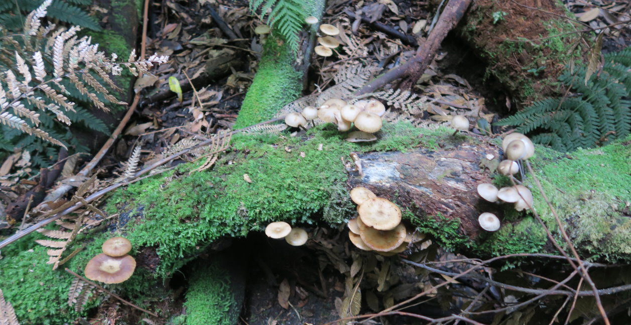
68) Cream mushrooms photographed in 2016-05
69) Cliffs

70) (Photograph taken in 2016-05)
DH in a circle of tree trunks - the remains of one giant Sassafras tree, Doryphora sassafras ~~~
Like their eucalypt cousins, these trees can recover after losing their main trunk. But instead of growing a single replacement trunk, a circular coppice of many trunks appears.

71) No Australian bush is complete without the ubiquitous Banksia.

Post Script
The pagodas are always interesting ... one would like to climb them all :-)
But the Dicksonia antarctica caterpillars are sheer fascinating. There are a few other gullies around this area. I wonder whether any of them is as interesting as Dicksonia Forest Ravine? Or is Dicksonia Forest Ravine unique?
Freda Moxom who was with Michael Keats party in 2015-05-07, has written a poem about the Dicksonias:
Gigantic caterpillars gently crawl past tangled vines along the valley floor
Ever so slowly multiplying as new ferns rise from their backs
Bright green fronds climbing out from Orang Utan tufts.
Slowly, silently and secretly they command the undergrowth
Iridescent fungi carpeting their feet.
They guard the Valley of Monoliths where huge stone gods rise above the massive trees
Whose dense and sparkling canopies shelter the ancient, twisted, gnarled and swinging vines growing amongst the waters, caves and secret slots.
Quietly, calmly and patiently the Caterpillar Ferns enrich their Gardens.
Visit them for their beauty
Admire them for their majesty
Protect them for they are priceless
Enjoy them; they are our world.
~~~~~ ~~~~~
In the above poem, the reference to monoliths are huge stone columns Freda saw in her 2015-05-07 trip. Some of the gullies they went to were different from the ones we visited today.
love this. going to do this one, thanx Paul.. Sam dworry
ReplyDeleteHi Sam, you'll like it :-)
Delete