2016 December: Day walk
Temple Slot, The Catacombs & Temple of Doom in Newnes State Forest, NSW, Australia
Prolog
Good to have HT leading us on an interesting walk in Maiyingu Marragu and Newnes State Forest
Five of us: HT, NC, FM, HK, me
High point of today's trip
Temple of Doom ... in particular, climbing up the 2 tall pillars at the northern end of Temple of Doom:

Another interesting feature in Temple of Doom is a rock called Temple Bath, discovered and named by FM in this trip ! ... see photos #71 and #72. It is at GR 332 089, at the southern end of Temple of Doom. I have since registered the name "Temple Bath" with Bush Explorers ... see this link:
http://www.bushexplorers.com.au/encyclopaedia/temple-bath
About Temple of Doom
- In Newnes State Forest
- A line of pagodas from GR 332 089 (southern end) to GR 332 092 (northern end)
- Just north of Blackfellows Hand Trail and about 2.5 km (as the crow flies) east of Wolgan Road
- Photos #59 to #73
About The Catacombs
- In Newnes State Forest
- From GR 329 095 (southern end) to GR 329 096 (northern end)
- An interesting series of narrow passages and tunnels along the headwaters of Temple Creek.
- Photos #46 to #53
About Temple Slot
- In Newnes State Forest
- A short narrow slot at GR 329 095, just west of The Catacombs
- Discovered and named by HT
- If you enter the slot on its western end, it will lead you closer to The Catacombs.
- Photos #39, #42 and #43.
Narrow slot in Maiyingu Marragu (Blackfellows Hand Reserve)
At the boundary of GR 318 095 & GR 319 095, there is a steep narrow slot on the north side of Blackfellows Hand Trail in Maiyingu Marragu (Blackfellows Hand Reserve).
It is next to an overhang, and its entrance is at a walking distance of about 450 meters from the carpark (the carpark meant for visitors to Blackfellows Hand Rock).
See photos #77 and #78.
Has a name been given to this slot yet ?
We didn't climb up the slot today. I'll do it 7 months later, in 2017-07. A report of the climb will be written up soon ... whatever soon means :-)
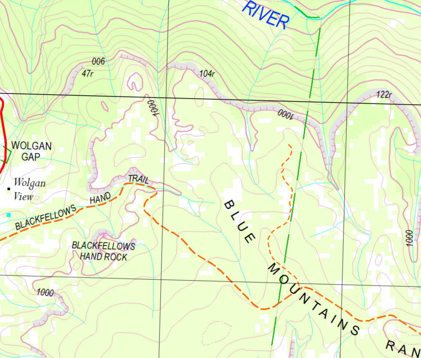
Maps
- 1:25,000 scaled 8931-3N Cullen Bullen
- 1:100,000 scaled 8931 Wallerawang
Here is the 1:25,000 scaled map of the relevant part of today's walk.
GPS tracklog file & Route
Our GPX tracklog file can be downloaded from:
https://drive.google.com/file/d/0B877-h5SCJaSYjBacDRHQVZ4aEE/view?usp=sharing
The same tracklog, red colour, clockwise direction, superimposed on the 1:25,000 scaled map:
- Turquoise dot: Where HT parks his car in Maiyingu Marragu (Blackfellows Hand Reserve) carpark meant for visitors to Blackfellows Hand Rock
(Scroll forward to the satellite images for more comments on the route.)

Satellite image of the tracklog in red colour, clockwise direction ~~~
- Turquoise dot: Where HT parks his car in Maiyingu Marragu (Blackfellows Hand Reserve) carpark meant for visitors to Blackfellows Hand Rock
(Scroll forward to a larger image for more comments on the route.)

A larger satellite image of the tracklog in red colour, clockwise direction ~~~
- Yellow arrow 1: Pagoda #1, GR 321 095
- Yellow arrow 2: Pagoda #2, GR 321 097
- Yellow arrow 3: Lookout #3, GR 318 101
- Yellow arrow 4: Pagoda #4, GR 318 100
- Yellow arrow 5: Temple Slot, GR 329 095
- Yellow arrow 6: Two tall pillars in Temple of Doom, GR 332 091 (close to the boundary of GR 332 092)
- Yellow arrow 7: Temple Bath, GR 332 089
- Yellow arrow 8: Narrow slot & overhang, boundary of GR 318 095 & GR 319 095
- Yellow oval: The Catacombs
- Turquoise dots: Temple Creek which flows north into Wolgan River

A summary of our route is:
- Start at Maiyingu Marragu (Blackfellows Hand Reserve) carpark
- Initially walk on Blackfellows Hand Trail
- Then get off Blackfellows Hand Trail to pagoda #1
- To pagoda #2
- To lookout #3
- To pagoda #4
- Through Temple Slot
- Explore The Catacombs
- To Temple of Doom, and climb up the 2 tall pillars
- To Temple Bath
- Investigate the inside of a narrow slot (Time: 15:11 to 15:24)
- Back at HT's car at the carpark
Timeline & Distance
09:23 0.0 km Start walking on Blackfellows Hand Trail
09:32 0.45km At overhang and entrance to narrow slot
09:35 0.5 km Resume walking
09:37 0.6 km Leave Blackfellows Hand Trail
09:49 0.9 km At pagoda lookout #1
09:51 0.9 km Leave pagoda lookout #1
10:03 1.35km At pagoda lookout #2
10:08 1.4 km Leave pagoda lookout #2
10:41 2.3 km At a lookout #3
Morning Tea
10:57 2.4 km Resume walking
11:01 2.45km At pagoda lookout #4
11:05 2.45km Leave pagoda lookout #4
12:11 4.2 km At Temple Slot ... discovered and named HT
Lunch
12:47 4.3 km Resume walking and start to squeeze through Temple Slot
12:53 4.3 km Exit Temple slot
12:57 4.35km Start of The Catacombs
13:06 4.55km As far as we go in The Catacombs
13:14 4.7 km Back at the start of The Catacombs
13:42 5.25km At northern end of Temple of Doom
Afternoon Tea
13:50 5.25km Start to climb up Temple of Doom
13:56 5.35km At the plateau of Temple of Doom
Climb up the 2 tall pillars of Temple of Doom
14:17 5.45km Resume walking southward
14:28 5.75km At Temple Bath ... named just now by FM
14:32 5.75km Leave Temple Bath
14:37 5.9 km At Blackfellows Hand Trail
14:39 5.9 km Resume walking along Blackfellows Hand Trail
15:11 7.8 km At overhang and entrance to narrow slot ... same spot as 09:32
Explore inside the narrow slot (but we didn't climb up the slot to the top of the cliffs.)
15:24 7.85km Resume walking along Blackfellows Hand Trail
15:32 8.3 km Back at HT's car
==============================================
Total: 6 hrs 9 mins
8.3 km Distance is from Google Earth
10.1 km Distance is from Garmin GPS
Pictures - Blackfellows Hand Trail
From where HT's car is parked, first walk on Blackfellows Hand Trail.
1) This interesting vertical slab of rock is by the side of Blackfellows Hand Trail ... about 150 meters from where we started walking.

Overhang & narrow slot
2) Still on Blackfellows Hand Trail ~~~
About 450 meters from the carpark, we come to an overhang and a narrow slot.
- Upper pic: In the middle of pic is a narrow slot ... see photos #77 and #78 for more photographs on this slot.
- Lower pic: (Continuation to the right of the upper pic) An overhang

To pagoda #1
3) We've left Blackfellows Hand Trail. There is a faint foot track which takes us to this cave.
Left to right: HT, NC, HK, FM

4) Walking further along ... interesting cliffs

5) More interesting cliffs

6) Through an enchanting valley

7) We marvel at the scenery around us.
Left to right: HK, NC, HT

8) Climb up this narrow passage ~~~
- Lower pic, left: Inside the passage ... HK is directly in front.
- Lower pic, right: At the top of the passage and looking back down

Pagoda #1
9) At pagoda #1 ~~~~
In the 3 pics below:
- Upper pic, left to right: NC, HK, FM, HT
- Middle pic, Left to right: FM, HK.
- Lower pic: The top of the pagoda

Pagoda #2
10) We've left pagoda #1, now at pagoda #2.
- Upper pic, top to bottom: FM, NC, HK
- Lower pic, top to bottom: HT, FM, NC, HK

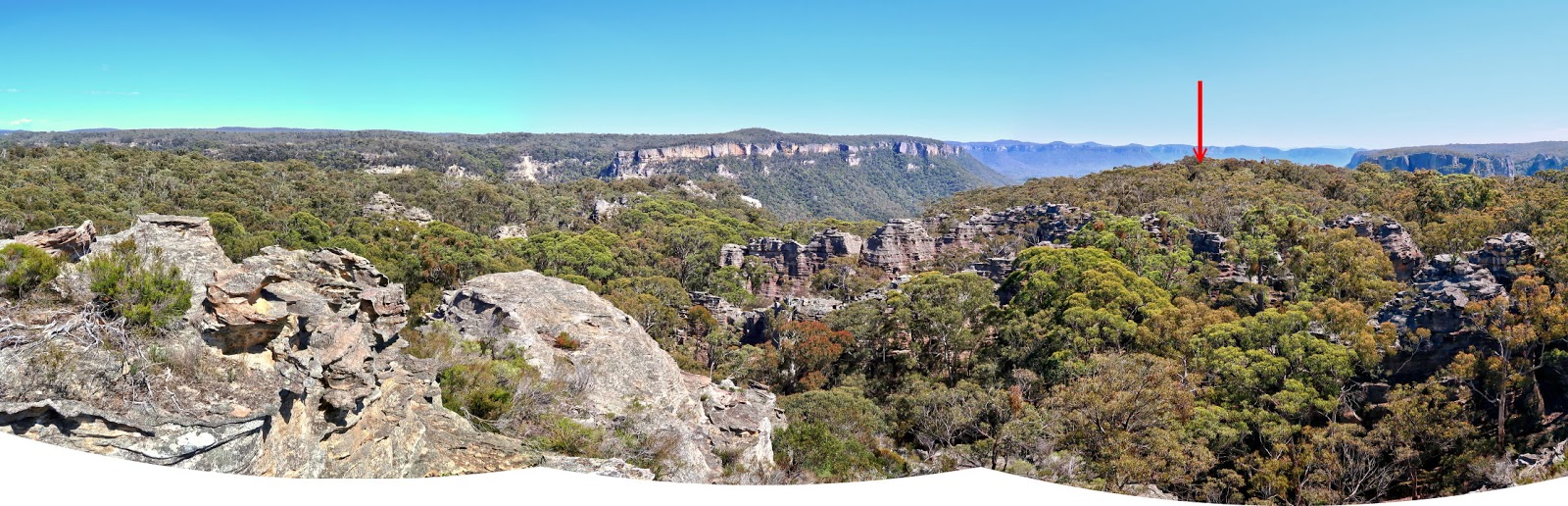
11) Panorama from the top of pagoda #2 ~~~~
Towards north is a small unnamed hill (red arrow) which blocks our view towards Wolgan Valley.
To lookout #3 (northern tip of today's trip)
12) Now walking towards north ~~~
Left to right: HT, HK, FM, NC

13) Passing some red cliffs

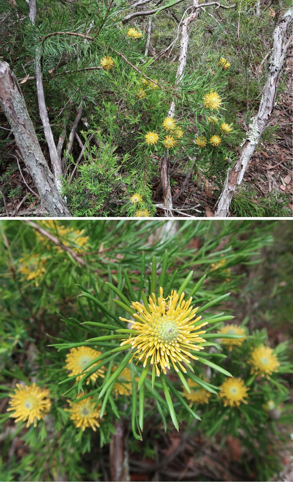
14) Passing this Leucochrysum graminifolium (Pagoda Rock Daisy) growing on a rock wall. It so happens that the sunlight makes it stand out prominently against the dark background.
- Lower pics: Zooming onto the Pagoda Rock Daisy from different directions.

15) Some kind of fungus?

16) About to enter another narrow passage (Turn right, into the gap between the rocks.) ~~~
Left to right: HK, FM, NC (HT is already inside the gap.)

17) We've turned into the narrow passage.

18) In the narrow passage ~~~
- Left pic: Same scene as above pic ... you should be able to make out features identical to both pics.
- Right pic: Inside the narrowest part (Another view of this narrow passage, from the opposite direction, is photo #28.)

19) We are out of the narrow passage of the previous pic.

20) The following 3 pics are of the same pagoda:
- Upper pic: South side of the pagoda
- Middle pic: West (long) side of the pagoda ... interesting jagged top !
- Lower pic: North side

At lookout #3
21) We come to this lookout which is as far north as we can go for today. For the purpose of this blog, I tag it is as lookout #3.
The large valley on the left half of this pic is Wolgan Valley. Both Wolgan road (which you should be able to see) and Wolgan River run along the valley.

22) This lookout is also a nice place for morning tea.
- Left to right: FM, HK, HT

Pagoda #4
We leave lookout #3, and go back in the direction where we came from (ie south).
23) HT leading us up to the top of pagoda #4 just south of lookout #3
(We could have climbed this pagoda while on the way to the lookout. But we didn't, and so doing it now.)

24) HT

25) At the highest point of the pagoda.
- Upper pic: FM
- Lower pic: HK and me

26) Leaving the pagoda ~~~
- The highest point in this pic is the same rock in the previous pic.
- Left to right: FM, HK, NC

27) FM is sliding down the pagoda. In front of her is HT.

Narrow passage - same as in photo #18
28) After pagoda #4, we retrace our steps back to the narrow passage as in photo #18.
Here, NC is in front of me.

Next destination - to Temple Slot
29) We are out of the narrow passage of the previous pic. Here are the sceneries on the way to Temple Slot.

30) This one is like a tunnel. HK is in front of me.

31) Another narrow passage ~~~
FM is in front of me. In front of her is HT.

32) The 2 pics below are continuation to the left/right of each other.
The main tree fern in both pics are of the same fern.

33) Beautiful open forest scene

34) Passing by this rock formation

35) What is the name of this flower?

36) Leptospermum, commonly known as Tea Trees.

37) More narrow passages

38) Interesting cliff top

Not long after the previous pic was taken, we cross from Maiyingu Marragu (Blackfellows Hand Reserve) into Newnes State Forest.
Temple Slot
39) We arrive at Temple Slot in Newnes State Forest.
The slot was discovered and named by HT.
- Left pic: NC is taking pictures of the slot.
- Right pic: I am standing at where NC was in the left pic. After lunch, we'll be walking inside the slot.

40) Time for lunch (Photograph courtesy of FM) ~~~
- Left to right: HT (discoverer of Temple Slot !), HK, me, NC

41) Nearby is this little pagoda.
The 2 photos below are of the same pagoda, taken from different directions.

42) After lunch, we walk through Temple Slot.
- Upper pic: FM is just about to enter the slot.
- Lower pics: It is the same rock feature in both red ovals.

43) We are out of Temple Slot and now look back at where we emerged out of it.

To The Catacombs
44) Walking to The Catacombs which is quite close to where we emerged out of Temple Slot

The Catacombs
The Catacombs is a series of narrow passages and tunnels along the headwaters of Temple Creek.
45) We drop our packs here and start going down The Catacombs.

46) Walking along The Catacombs

47) The Catacombs is a wonderful place !
- Upper pic: HK is leading. NC is behind her.
- Lower pic: One can go along the yellow arrow as FM has already done so. Or go down on the left side as NC is doing now. (A second later, NC turns around and goes along the yellow arrow too; but either way is ok.)

Afterwards there is hole to crouch through, see photo #50.
48) This is as far north as we go in The Catacombs.
We now retrace our steps back to where we dropped our backpack (photo #45).

Retrace steps back out of The Catacombs
49) We came from this hole, now we go back through the same hole.

50) HK is already inside the hole of the previous pic.

51) Now in the same area as in photo #47

52) More of the narrow passages in The Catacombs
- Upper pics: HK
- Lower pic, left to right: HT, HK, FM

53) Close to where we drop our backpack in photo #45.

54) We've picked up our backpacks, now leaving The Catacombs.
This pic and photo #45 are taken near the same spot, but facing opposite directions.

To Temple of Doom
55) On our way to Temple of Doom ... Interesting mineral vein on the rock face

56) Scenery along the way to Temple of Doom

57) Isopogon anethifolius (Narrow-leafed Drumsticks)
58) I wonder what is the name of this flower?

2 tall pillars of the Temple of Doom
59) Arrive at Temple of Doom ~~~
In the 3 pics below:
- Red arrow: 1st pillar in temple of Doom.
- Blue arrow: 2nd pillar.
Some of us will climb to the top of the pillars later on.

60) HK making her way gingerly along the rock face of the 2nd pillar

61) Top to bottom: HT, FM, NC
- A little further ahead of HT is a plateau-ish sort of area where we'll take a rest. Some of us will then climb the 2 pillars.
- Blue arrow (upper-right corner): 2nd pillar

62) Wonderful panorama of the two tall pillars in Temple of Doom (Photograph taken from the plateau-ish sort of area just a little bit further ahead of HT in the previous pic)
- Red arrow: 1st pillar in temple of Doom
- Blue arrow: 2nd pillar.

63) - Upper pic: Continuation to the right of previous pic (ie photo #62)
- Lower pic: A mass of pagodas along the eastern bank of an unnamed creek. This scene is zooming into the right side of the 2nd pillar in photo #62

64) The wonderful tall pillars of the Temple of Doom
- Red arrow: 1st pillar
- Blue arrow: 2nd pillar

65) NC, FM and I climb the 1st pillar.

66) NC and I climb the 2nd pillar (photograph courtesy of NC's camera)

The rest of Temple of Doom
67) Still at the two tall pillars area ... and looking south ... we are heading that way now, and will go along the 2 yellow arrows to return to the car. Blackfellows Hand Trail is along the horizontal yellow arrow.

68) Leaving the two tall pillars area ~~~
HT is leading, followed by NC, HK, FM.

69) Another Leucochrysum graminifolium (Pagoda Rock Daisy) ... the other one is in photos #14.
They only grow in the Lithgow/Newnes district and no where else in the world. And they only grow on exposed pagoda-like rock formations, and require hardly any soil.

70) Some interesting pagodas in the Temple of Doom area

Temple Bath
Location: GR 332 089
71) Not too far to Blackfellows Hand Trail, FM discovers the rock on the left side of this pic. She christens it Temple Bath.

72) We pose on the Temple Bath. (Photographs courtesy of NC)
- Upper pic, left to right: HK, FM
- Lower pic, left to right: HK, me, FM, HT

73) Scenery from Temple Bath ~~~
- Red circle: We didn't go anywhere near this pagoda. But it would be interesting to climb it in a future date.
- Red arrow: Towards north, in the direction where we just came from ... We didn't climb this one too. We skirted behind it (ie on its east side). But 7 months later, in 2017-07, I will be climbing it. A report on the 2017-07 trip will be written up soon ... whatever soon means :-)

Blackfellows Hand Trail
74) We are now on Blackfellows Hand Trail ~~~
This Boronia (maybe B. algida or B. microphylla ???) is growing by the side of the trail, near the border of Newnes State Forest and Maiyingu Marragu (Blackfellows Hand Reserve).

Then, we cross from Newnes State Forest into Maiyingu Marragu.
75) A termite mound ... we are now in Maiyingu Marragu (Blackfellows Hand Reserve).

76) Still on Blackfellows Hand Trail ~~~
We are quite close to the overhang and narrow slot of photo #77.

Overhang & narrow slot
77) We are back at the overhang and narrow slot of photo #2.
- Upper pic: The overhang
- Lower pic: The narrow slot is the dark vertical fissure between the 2 rock cliffs.

Narrow slot - does it have a name?
We go to check out the inside of the narrow slot of the previous pic.
The slot is a steep climb to the top of the cliffs. But its narrowness deter us from venturing far inside. However ...
78) ... However, FM is adventurous. In the lower right pic, she squeezes in sideways like a crab, and climbs almost to the top. Well, she is indeed slim ! On seeing none of us are interested to follow her, she didn't venture out the other end.
But 7 months later, in 2017-07, I will climb all the way to the top. A report on the 2017-07 trip will be written up soon ... whatever soon means :-)

Back to car
79) Then it is back to HT's car in the Maiyingu Marragu carpark (the carpark for visitors to Blackfellows Hand Rock).
- Left to right: FM, NC, HK, HT

Post Script - Blackfellows Hand Rock
Before driving home, we go to take a look at the nearby Blackfellows Hand Rock. Photos and trip report are in this link:
http://mntviews.blogspot.com.au/2016/12/blackfellows-hand-rock-maiyingu-marragu.html
No comments:
Post a Comment